Tuesday, November 20, 2012

Huayna Potosí


My brother told me about a mountain he climbed while he was traveling in Bolivia many years ago. The famous mountain is called Huanya Potosi and he suggested that I try and climb it while I am in La Paz. This sounded like a great idea so I hired a guide and equipment and took a two day journey to the mountain. On the first day we hiked to high camp, elevation 5200m and left for the climb at 1am. Arriving on the summit at around 5:30 am just as the sun was getting ready to rise on the horizon. I wanted to stay longer on the summit to wait for the sun to rise higher however my guide insisted that we go down after only 20 minutes on top of the peak. The views from the top were unbelievable and the climb down was visually very spectacular as you could see Lake Titicaca and the other mountains of the Cordillera Real in the distance. Summer rainy season is starting in Bloivia so we were lucky to have good weather this morning as it was very overcast the previous days before. It is a beautiful mountain and this climb has probably been the highlight of my South American trip so far. Hopefully I can spend more time climbing in the Andes in the future.
Huanya Potosi is only 25 km north of La Paz in the Cordillera Real and is the closest mountain to the city and is a very popular mountain to climb in Bolivia. The altitude is 6088m (19,974 ft) and the normal ascent route is a fairly straightforward glacier climb, with some crevasses and a steep climb to the summit. The final approach is fairly exposed on both sides and the summit is small and forms a cornice.The climb down to the high camp was very pleasant and swift and before I knew it I was back in the belly of La Paz looking back at the soaring peak in the distance. 


Bolivian mt. guide


obligatory summit photo


French climber welcoming the sun


waiting for the sun

el alto lights in the background (la paz urban sprawl)


high camp


Huanya Potosi (not my photo-credit unknown)

Wednesday, November 14, 2012

Puno to La Paz - Bolivia

on the road to Bolivia

Nov, 7 Puno to Juli
Nov, 8 Juli to Copacabana
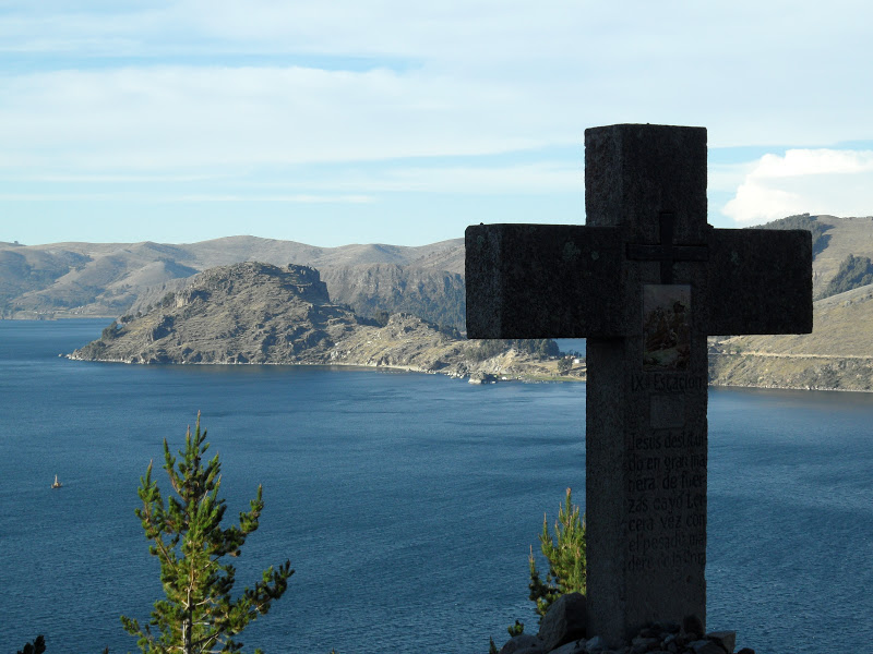
Nov, 9 boat to Isla del Sol
Nov, 10 explore Isla Del Sol
nov, 11 Copa to Huarina
Nov, 12 Huarina to La Paz

From Puno I continued south along the coast of Lago Titicaca. Titicaca is a lake in the Andes on the border of Peru and Bolivia. It is the largest lake in South America, elevation 3,812 m (12,507 ft). Five major river systems feed into Lake, one of the many islands on the lake is Isla del Sol (island of the sun). According to Inca legend this island was where the sun originated.
After a pleasant ride I made to Juli and then the next day crossed the border into Bolivia, payed the 135$ visa fee required of American passport holders and got a 3 month visa, then continued onto Copacabana. The day after I went about 17 km on a dirt road to the end of the peninsula and got a boat to Isla del Sol where I explored the island and spent the night. From Copa went over the hill and down the other side, crossed the lake with the ferry and kept riding until it got dark, did not find any accommodation so set up my tent on some farm land next to the highway. The next morning after a couple hours I was all of a sudden on the outskirts of La Paz in a area called El Alto which seemed to go on forever. Finally came to the valley where La Paz lies and rode down the steep and windy streets into the city. I am staying at a casa de cyclistas that I found through WarmShowers, there are many other cyclists staying at the house and it has been nice to connect with other people traveling by bike. I like it here. Planning to spend some time in the mountains around La Paz, visit Tiahunaco and study some Spanish before continuing south.


urban Puno


Juli


Isla del Sol


going up

crossing the lake with ferry
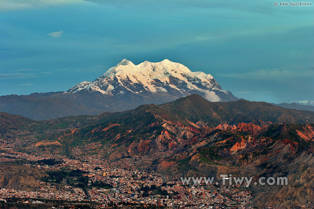


La Paz

Tuesday, November 6, 2012

Cusco to Puno


Nov,1 - Cusco to Urcos
Nov,2 - Urcos to Sicuani
Nov,3 - Sicuani to Aguas Calientes
Nov,4 - Aguas Calientes to Ayaviri
Nov,5 - Ayaviri to Puno (via bus)
Nov,6 - rest day Puno
 
I rolled out of Cusco on the 1st of November and continued moving south, it was a gradual downhill most of the way to Urcos where I stayed for the night, an hour or so after leaving Cusco it began to rain and I took cover in an abandoned building and then made it to Urcos in the early afternoon. The next day I had to contend with more rain and headwinds and arrived in Sicuani. The day after I began the climb up the Abra La Raya (alt. 4338 meters), this would be the last major climb before entering the high altitude plains that reach lake Titicaca and the Bolivian border. Climbing higher through the valleys I could see some very dark looking clouds in the distance and was also feeling a bit weak perhaps from the altitude. Then i rounded a corner and saw a sign for some hot springs, this was a very welcome sight, so I paid to enter and had a nice soak and then it began to rain heavily. At this point I decided to stay here for the night and was put up in a grungy cement cell. The day after I went over the pass and down the other side to Ayaviri. It was Sunday afternoon when I arrived in the central Plaza and found another simple room for the night. The following day I decided to take a bus to Puno after hearing that there was heavy traffic with very little shoulder on the highway and unimpressive scenery. When I arrived in Puno I found that it was the annual town celebration so spent the afternoon enjoying the carnival and procession through the streets.